Senderismo por rutas nuevas || Hiking new routes
Senderismo por rutas nuevas || Hiking new routes
Desde hace unos meses estoy saliendo a caminar con más regularidad para despejar la mente, tomar algunas fotos y ejercitarme. Eso ha implicado que pregunte sobre algunas rutas o caminos que toman las personas pero aún me faltan por conocer. Recorrerlos solos me ha permitido estimar si podré hacerlos luego con mi esposa. Hace unos meses atrás recorrí un camino de esos, y luego la invité a recorrerlo juntos. Ella aceptó un día que visitaríamos a unos amigos. Aquí les muestro cómo fue el trayecto.
La ruta empezaba por una calle pavimentada y llena de casas. Pero poco después se transformaría en un camino angosto en una zona boscosa. Caminaríamos por la falda de una montaña e implicaba cruzar un rio, para finalmente llegar al trayecto más inclinado. Entonces llegaríamos a otra calle pavimentada en el sector donde viven nuestros amigos. Llevaba mi cámara para las fotos mientras que el teléfono estaba haciendo las mediciones de la actividad con las aplicaciones Strava y Relive.
Empezamos el recorrido con un día mayormente soleado. Para estos casos es bueno llevar un calzado cómodo y que no sea tan resbaladizo.
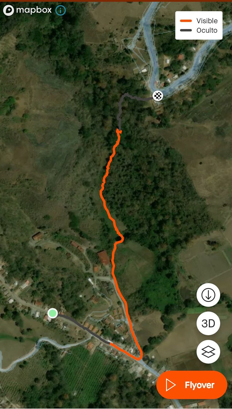
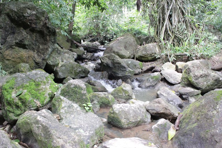
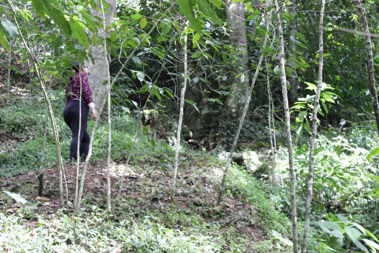
No sé por qué, pero la aplicación Strava marcó con un color diferente al principio y al final del recorrido que hicimos. Como se ve en ésta imagen, empezamos en una zona poblada. Al dejar atrás las últimas casas nos adentramos a la zona montañosa. Ese es un camino que suelen usar los agricultores de la zona, esto hace de que esté bien demarcado. Recientemente habían cortado la maleza en algunas zonas, haciendo que tuviéramos vista privilegiada a algunas zonas más bajas.
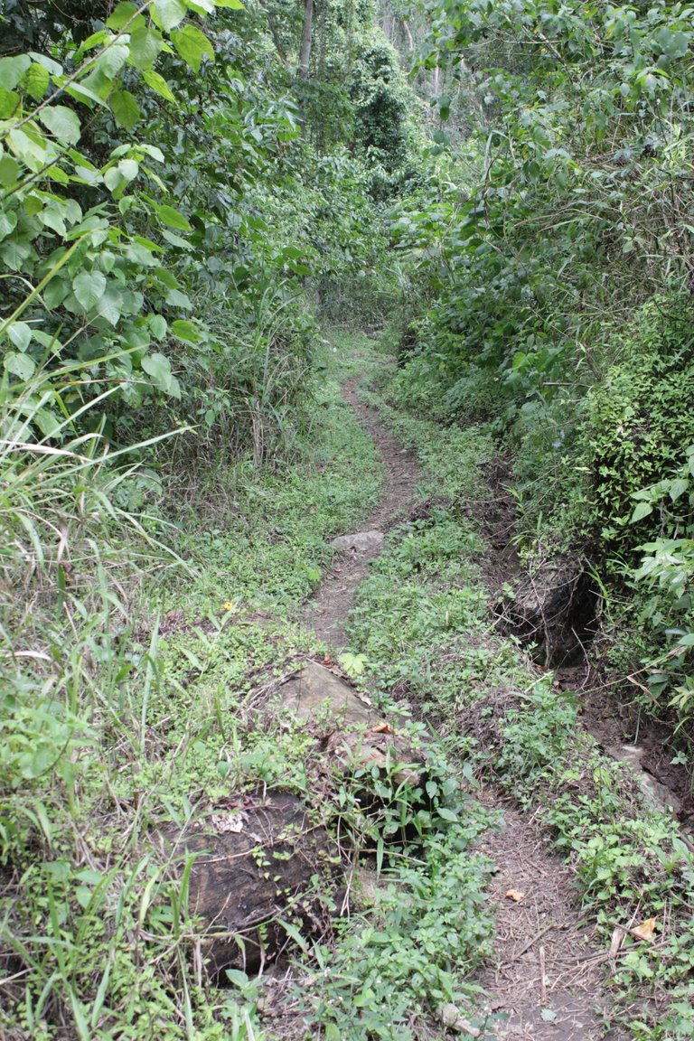 | 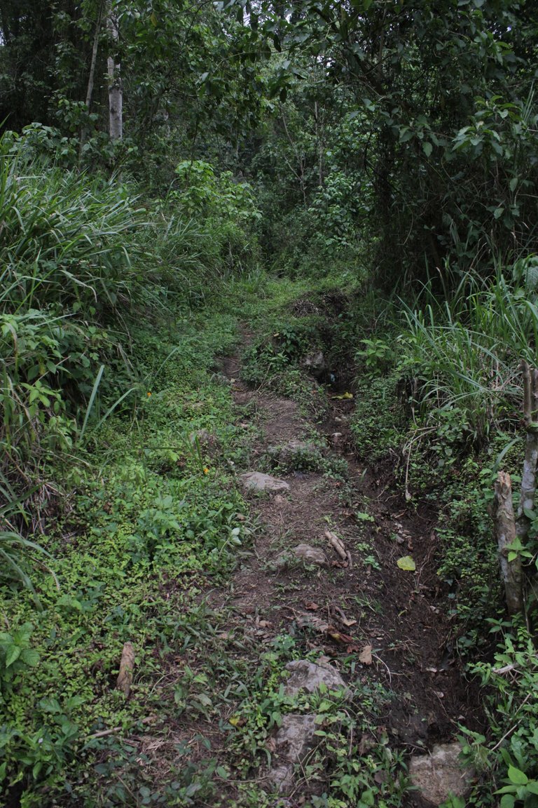 |
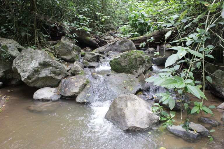
El camino tenía subidas y bajadas moderadas, al menos para mí. No podíamos distraernos. Había muchos sonidos naturales, de pájaros y viento entre las hojas de los árboles. También habían grandes troncos caídos atravesados en el camino que había que pasar por encima de ellos. Había mucha actividad de bachacos y hormigas trasladándose. Realmente fue una experiencia muy rica para los sentidos, la paz y el contacto con la naturaleza.
 | 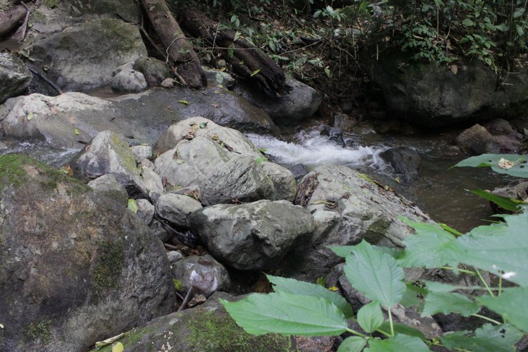 |  |
Entonces llegó el momento de atravesar el río. No tiene puente, así que hay que atravesarlo pisando sobre las piedras, literalmente. Había una corriente considerable, aunque lo he visto más fuerte. Es el mismo que he visitado pero en una parte más alta, que por cierto, pensamos ir pronto. Aprovechamos de tomarnos varias fotos mi esposa y yo, y con cuidado pasamos el río.
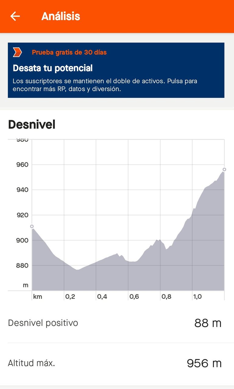
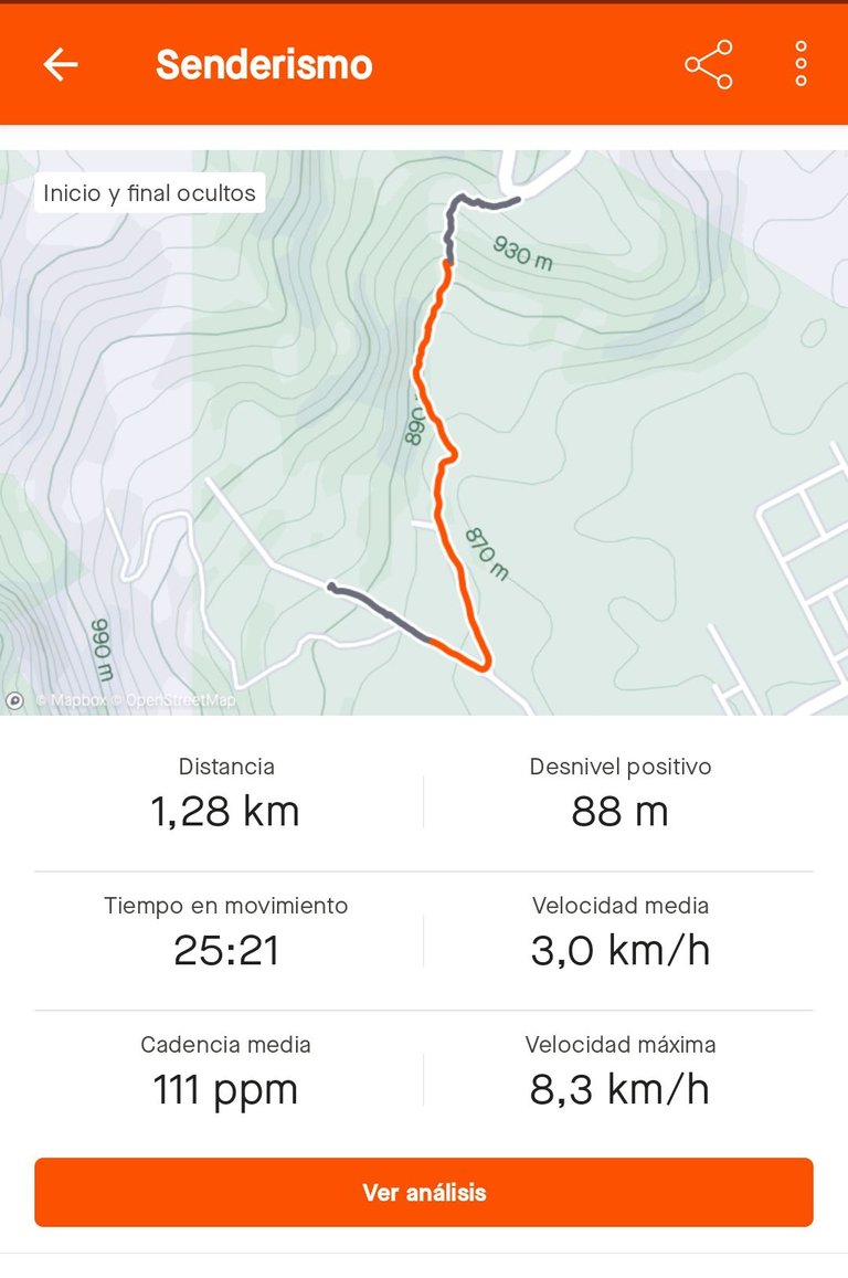
Ésa fue la última parte más divertida. Ahora nos quedaba el último tramo que era bastante inclinado. Como ven en éste maravilloso gráfico, prácticamente ascenderíamos unos 60 metros sobre el nivel del mar en menos de 300 metros de distancia. Nos detuvimos en algunos segmentos para descansar y otros para ver por dónde pasaríamos, en vista de que el agua corriendo producto de las lluvias había destruido algunos pequeños tramos del camino.
Cabe destacar que cuando hice por primera vez ésta ruta la hice al revés de como lo hacíamos esta vez, así que la hice descendiendo. Y en esa oportunidad me caí en ésta pendiente, dos veces. Así que ya conocía lo difícil que sería subirla. Afortunadamente estaba seca. Mojada sería otra cosa.
Luego de éste trayecto, llegamos a la población que visitaríamos. Fue muy satisfactorio hacer ésta actividad juntos, sin estrés. Las fotos que tomó mi esposa son muy divertidas. Pero éste post se centra más que todo en el esfuerzo físico que tuvimos y en el lenguaje técnico que nos aportan las herramientas digitales para medir nuestras actividades. Por cierto, aquí está la última de Strava que muestra un excelente resumen de las mediciones.
Recomiendo altamente éstas actividades en familia, porque nos ayuda a unirnos y disfrutar de cosas buenas y bonitas, tener conversaciones relajadas y soltar un poco los dispositivos. Aunque, yo no las solté del todo, porque íbamos tomando fotos por el camino. Bueno, que sea sólo para eso. ¡Hasta la próxima!


For the past few months, I have been going out for walks more regularly to clear my mind, take some photos, and exercise. This has involved me asking about some routes or paths that people take but I still have some to discover. Walking them alone has allowed me to assess if I will be able to do them later with my wife. Some months ago, I walked one of these paths, and then I invited her to walk it together. She agreed one day that we would visit some friends. Here, I show you how the journey went.
The route began on a paved street full of houses. But shortly after, it would transform into a narrow path in a wooded area. We would walk along the foothills of a mountain and it involved crossing a river, to finally reach the steepest section of the trail. Then, we would arrive at another paved street in the area where our friends live. I brought my camera for photos while my phone was tracking the activity with the Strava and Relive apps.
We started the journey on a mostly sunny day. For such cases, it is good to wear comfortable footwear that is not too slippery.
I don't know why, but the Strava app marked the beginning and end of our journey with a different color. As seen in this image, we started in a populated area. Leaving behind the last houses, we entered the mountainous area. This path is commonly used by local farmers, which ensures it is well-marked. Recently, they had cleared some overgrown areas, giving us a privileged view of lower areas.
| |
The path had moderate inclines and declines, at least for me. We couldn't get distracted. There were many natural sounds, of birds and wind rustling through the leaves of the trees. There were also large fallen tree trunks blocking the path that we had to climb over. There was a lot of activity of leafcutter ants and other ants moving about. It truly was a rich sensory experience, peaceful and in touch with nature.
| | |
Then came the moment to cross the river. There was no bridge, so we had to step on the stones to get across, literally. There was a significant current, although I've seen it stronger before. It's the same river I have visited but in a higher part, which we are planning to go to soon. My wife and I took several photos, and carefully crossed the river.
That was the most fun part. Now we had the last section left, which was quite steep. As you can see in this wonderful graph, we would ascend about 60 meters above sea level in less than 300 meters of distance. We stopped at some segments to rest, and others to figure out where to pass, considering that the water running due to the rains had destroyed some small sections of the path.
It's worth noting that when I first did this route, I did it in reverse of how we were doing it this time, so I did it descending. And on that occasion, I fell twice on this slope. So, I already knew how difficult it would be to climb it. Fortunately, it was dry. It would have been another story if it was wet.
After this trek, we arrived at the town we were visiting. It was very satisfying to do this activity together, without stress. The photos my wife took are very fun. But this post focuses mostly on the physical effort we put in and the technical language provided by digital tools to measure our activities. By the way, here is the latest Strava post showing an excellent summary of the measurements.
I highly recommend these family activities because they help us bond and enjoy good and beautiful things, have relaxed conversations, and release our devices a bit. Although I didn't completely let go of them because we were taking photos along the way. Well, let it be just for that. Until next time!
🏃♂️

FUENTES / SOURCES
Imágenes: Realizadas con mi cámara Canon Rebel EOS t3i y editadas con GIMP // Images: Shot with my Canon Rebel EOS t3i camera and edited with GIMP
Banner: Hecho por mi en GIMP con imágenes propias y recursos gratuitos del sitio pfpmaker.com/ // Banner: Made by me in GIMP with my own images and free resources from the site pfpmaker.com/
Idioma: Post redactado en español y luego traducido al inglés mediante hivetranslator.com por @noakmilo // Language: Post written in Spanish and then translated into English through hivetranslator.com by @noakmilo
Posted Using InLeo Alpha
https://inleo.io/threads/aaalviarez/re-aaalviarez-wufz2f6c
The rewards earned on this comment will go directly to the people ( aaalviarez ) sharing the post on LeoThreads,LikeTu,dBuzz.
Gracias por el apoyo @rutablockchain
Que bien que hayas emprendido el senderismo con tu esposa, más por una ruta nueva, el contacto que tenemos con la naturaleza en esas actividades, es mágico, la buena vibra que se siente, lo bueno de Respirar en eso lugares, te relaja y conforta mucho. Sigamos en la práctica, saludos 😘🤗
La respiración es muy diferente. Se nota la diferencia en esos lugares y los más urbanos. Creo que eso es una de los grandes beneficios. Gracias por pasar por aquí. Saludos @neilamarcano
Así es, se respira mejor en esos lugares, vamos por más, saludos
Que buena ruta amigo me gusta mucho esa zona boscosa, se nota un clima agradable para hacer senderismo 👍
Sí, y como implica esfuerzo físico, uno se detiene a descansar y aprovechar de ver a nuestro alrededor y admirar la naturaleza. Gracias por apreciar el contenido. Saludos @yolimarag
!BBH
@yolimarag! Your Content Is Awesome so I just sent 1 $BBH (Bitcoin Backed Hive) to your account on behalf of @aaalviarez. (2/5)
Saludos amigo, que bueno, hayas comenzado a practicar senderismo, la ruta se ven boscosa y bien agradable para disfrutar con la naturaleza, te felicito.
Sí, lo disfruté mucho. Como dije al principio, estoy saliendo más a menudo por esas zonas, sólo que no hago las mediciones, porque me detengo mucho por el camino, a tomar fotos y eso. Gracias por apreciar el contenido. Saludos @cetb2008
!BBH
@cetb2008! Your Content Is Awesome so I just sent 1 $BBH (Bitcoin Backed Hive) to your account on behalf of @aaalviarez. (3/5)
Congratulations @aaalviarez! You have completed the following achievement on the Hive blockchain And have been rewarded with New badge(s)
Your next target is to reach 4250 replies.
You can view your badges on your board and compare yourself to others in the Ranking
If you no longer want to receive notifications, reply to this comment with the word
STOPCheck out our last posts:
El senderismo es una actividad que he querido desde hace tiempo mi localidad no tiene la zona para ello. Lo que si es estoy consciente del beneficio para la salud, tener contacto con la naturaleza y apreciar los diferentes paisajes. Que bueno que hayas compartido tu experiencia con nosotros.
Saludos.
Tal vez con planificación puedas realizarlo junto a otros en un feriado o fin de semana. Seguro tendrás muchos beneficios y fotos espectaculares. Saludos @franz54
Nos encanta, cuando los que hablamos, debatimos y/o escribimos sobre deportes, lo practiquemos. No sé si está bien o mal, mi forma de pensar, pero me alegra en demasía que hayas arrancado con el senderismo y más aún, acompañado por tu esposa. ¡Un genial plan!
Gracias por compartirlo en la comunidad, estimado amigo.
Un abrazo.
Sí, hay que practicar lo que se predica, ¿no? Bueno, en realidad llevo tiempo con eso, como digo al principio del post. Pero no llevo la medición ni voy con la intención de publicarlo, entonces, bueno, no tengo material de calidad para preparar post de cada ocasión. Y también ando en bicicleta regularmente, por eso disfruté mucho aquel video que hiciste con "La Pelu". La actividad física es muy importante. Creo que es una de las cosas que nos recordó muy bien la pandemia. Saludos @palabras1
Qué genial sería verte en bicicleta, mostrándonos los lugares de zona de residencia. La vista, desde la bicicleta, es única.
Un abrazo.
Estoy pensándolo, pero no tengo los equipos para hacer unas buenas tomas. Videos como los tuyos me animan mucho a intentarlo. He visto como algunos sujetan su teléfono a su cuerpo o al volante de la bicicleta. Pero bueno, aún no me he puesto a ensayar. Me gustaría tener una cámara especial para eso, pero no puedo invertir en eso ahora. Espero llegue ese momento algún día. Gracias por tu ánimo